A Starry Map

Source of the map: https://commons.wikimedia.org/wiki/File:MODIS_-_Great_Britain_-_2012-06-04_during_heat_wave_(cropped).jpg

Source of Henry Holiday's front cover illustration to Lewis Carroll's 'The Hunting of the Snark': https://snrk.de/snarkhunt/

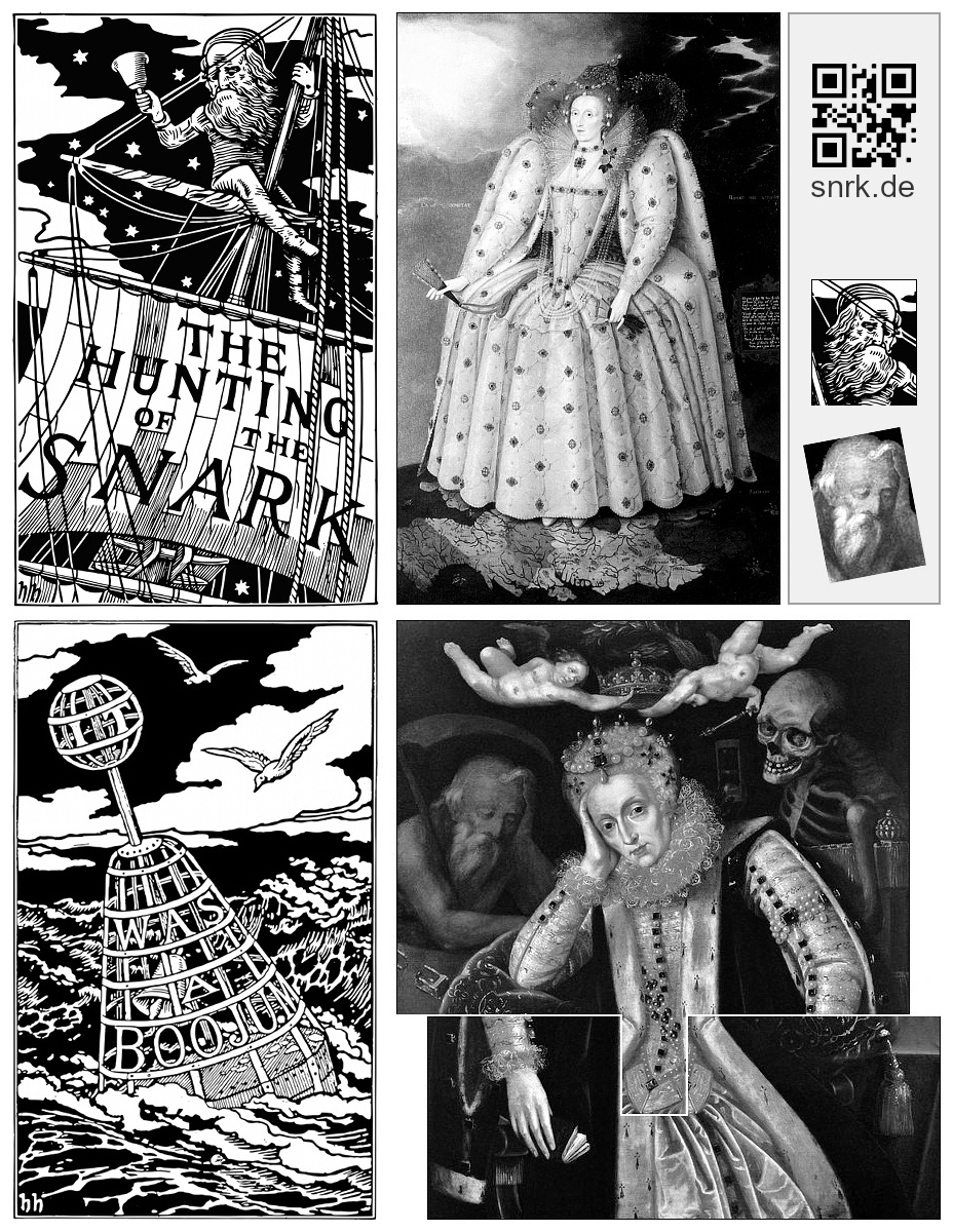
John Tufail’s “The Illuminated Snark” (p. 15) lead me to this comparison. In 2004 he interpreted the starry night sky in Henry Holiday’s front cover illustration to Lewis Carroll’s “The Hunting of the Snark” (1876) as a map, where the white clouds represented land with rivers. I liked the suggestion, but did not find any real-world map to which Holiday might have alluded. Holiday engraved that illustration himself.

I discovered John Tufail’s paper in 2009. Only today, after 15 years, I got the idea to compress and flip a large segment of a map of the British isles vertically. That’s my “slowness in taking a jest”. You see the result. Sadly, I can’t tell John that anymore. I appreciated his guidance a lot. The white clouds weren’t the land, but as for a map having been hidden in the illustration, John was right.

 
For comments: reddit: r/LewisCarroll, r/Maps, r/MapPorn

 
2024-05-12, update: 2024-06-25

When the Queen met the Boojum

This is the first page published in snrk.de, a blog which was set up in 2017. It’s mostly about Lewis Carroll‘s, Henry Holiday‘s and Joseph Swain‘s illustrations to The Hunting of the Snark.

In his Illuminated Snark, John Tufail assumed that the night sky in the front cover of The Hunting of the Snark could be a map. Together with my assumption that Henry Holiday drew inspiration from several paintings by Marcus Gheeraerts (I+II), John’s paper helped me to find the Ditchley Portrait. That again helped me to find the painting by an unknown artist depicting Elizabeth I at old age.

It took me several years to find another map to which Henry Holiday might have referred as well.

more

 
2017-08-28, update: 2024-05-12

The Ocean Chart

Lewis Carroll’s The Hunting of the Snark (1876) has been published “with nine illustrations by Henry Holiday”. But there are ten illustrations. One possible explanation: The Ocean-Chart (aka the Bellman’s map) has been made neither by Henry Holiday nor by Joseph Swain, but by a typesetter.

In the more recent British history, the map has been used by Britain’s contemporary Bellmen before 2016-06-23 to present their understanding of the impact of the Brexit to the rest of the crew. Admittedly, by now the majority of Britains understand the trouble they put themselves into. But as pride and face-saving of course is much more important than something profane like a healthy economy and rational thinking, that map won’t be updated.

more

 
2017-09-29

Consent Management Platform by Real Cookie Banner